CALIFORNIA 2024
Spirit of Shasta
June 22 - 29, 2024
We had a fantastic route planned in 2018 – but a wildfire caused us to move the entire event to Oregon at the last minute. Well, for 2024 we’re going there – and we’ve made some changes we think you’ll like.
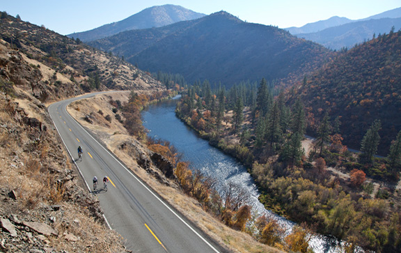
First, the main thing: The rugged natural beauty of far-northern California is still sublime. Riding for miles and miles next to the meandering Klamath River on Day 1 sets the tone, as we explore roads, towns and terrain few ever take the time to explore and enjoy. Day 2 offers a stellar climb on one of the least-traveled roads in the state. On Day 3 we’ll continue the low-traffic riding on the secluded and wild Scott River Road. Day 4 switches to the wide-open agricultural beauty of the Scott Valley. On Day 5 it’s another lightly-used road that drops down a canyon on a spectacular, twisting joyride. Day 6? Merely the Queen Stage of the week, as we ascend the slopes of Mt. Shasta steadily up to nearly 8,000 feet – and then glide back down. Day 7 takes us into backcountry range before we return to Yreka for the finish.
The main change is that we’ll have three – yes, three – layover days on this route. You’ll get an extra day in Happy Camp, Etna and Weed, each of which offers its own quirky charm. Three days where you can ride, explore, or both… and no one has to move to a new camp. We’ll have special activities on all those days, to make this a truly memorable BRNW adventure.
Come with us, to experience the true spirit of Shasta.
Rider Feedback:
“The rides have a good mix of repeat and new riders that really creates great camaraderie.’”
CALIFORNIA 2024 ROUTE DETAILS

| Day | Description | Distance (miles) |
Elevation Gain (feet) |
|---|---|---|---|
| 1 | Yreka to Happy Camp | 71 | 4,130 |
| 2 | Happy Camp Layover: Oregon Border Up-and-Back | 42 | 5,025 |
| 3 | Happy Camp to Etna | 69 | 5,335 |
| 4 | Etna Layover: Scott Valley Loop | 50 | 1,670 |
| 5 | Etna to Weed | 53 | 3,530 |
| 6 | Weed Layover: Mt. Shasta Up-and-Back | 54 | 5,765 |
| 7 | Weed to Yreka | 45 | 1,380 |
| TOTAL (with option) | 384 | 26,835 |
CALIFORNIA 2024 DAILY ROUTES
Notes: The routes will be updated with details and possibly changed before the ride. Also, the elevation profiles below use different scales; make sure to check the scale when judging climbs and comparing days. It’ll make you feel better.
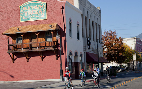
Day 0 – Saturday, June 22: Check-in, Yreka
Site: Jackson Street Elementary School Map
Local lodging (PDF)
We’ll gather in historic Yreka, once home to a bustling mining economy. The downtown has a strong flavor of Old West, offering plenty of opportunities to explore once you arrive. In camp, you’ll check in and renew old acquaintances even as you begin meeting new friends.
Day 1 – Sunday, June 23: Yreka to Happy Camp – 71 miles, 4,130 feet of gain RWGPS route file
Site Location: Happy Camp River Park Map
Local lodging (PDF)
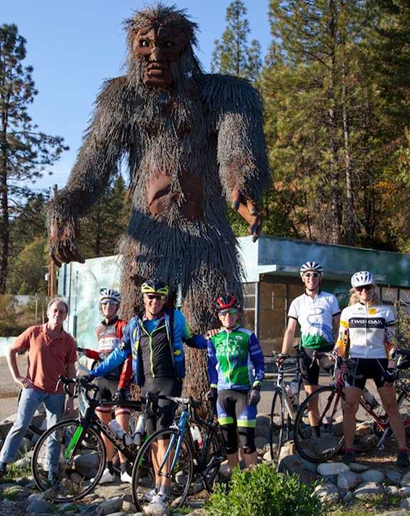
The tone for the week is set within the first 10 miles: Wow. After riding through Yreka’s historic downtown, quickly you’re pedaling a serpentine canyon, crossing dizzying bridges above the Shasta River far below. The rest of the day is a riverside odyssey, following the seemingly capricious flow of the Klamath to the unique outpost of Happy Camp, where Sasquatch is seen every day and we’ll camp on the banks of the river.

Day 2 – Monday, June 24: Happy Camp Layover: Oregon Border Up-and-Back – 42 miles, 5,025 feet RWGPS route file
Site Location: Happy Camp River Park Map
Local lodging (PDF)
Our first layover offers a challenge you can customize, taking on as much climb as you want before turning back. Grayback Mountain Road is a stellar example of the kind of “why is it there?” roads you can find in the Northwest. It winds up and up, at a reasonable pitch, until the summit near the Oregon border. Witness the ghostly beauty of a post-fire forest as you zen out on the quiet climb.

Day 3 – Tuesday, June 25: Happy Camp to Etna – 69 miles, 5,335 feet RWGPS route file
Site Location: Johnson-Joss Memorial Park Map
Local lodging (PDF)
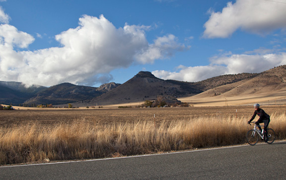
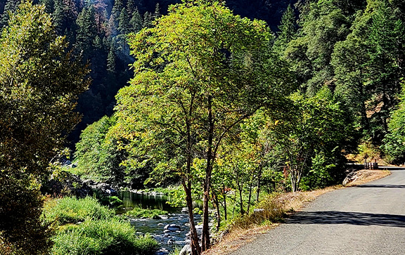
If you thought the ride along the Klamath felt remote, wait until we turn off this morning and follow the Scott River as it snakes through deep woods on a road that’s sometimes only a lane wide. Cross the river numerous times before emerging from the forest into the verdant Scott Valley, where we’ll ride through the land of the Quartz Valley Tribe on our way into Etna and our shady park home for the next two nights.

Day 4 – Wednesday, June 26: Etna Layover: Scott Valley Loop – 50 miles, 1,670 feet RWGPS route file
Site Location: Johnson-Joss Memorial Park Map
Local lodging (PDF)
Give your legs a refresh day with a shorter, flatter but eminently pleasant ride through the Scott Valley. Along the way you can check out the roguish charm of the Callahan Emporium, explore a working winery at a rest stop, and visit historic Fort Jones. Riding on local backroads, you can really relax and take in every detail of the pastoral landscape. The elevation profile below is a great example of “relative scale.”

Day 5 – Thursday, June 27: Etna to Weed – 53 miles, 3,530 feet RWGPS route file
Site Location: Bel Air Park Map
Local lodging: Find local listings here.
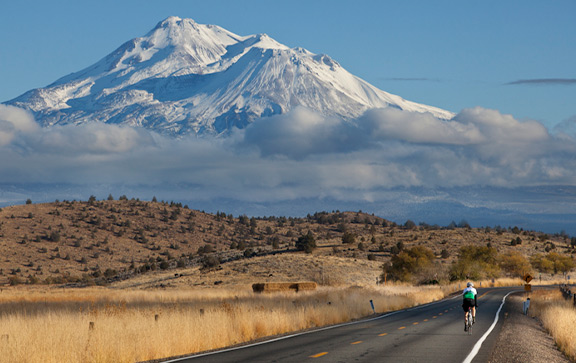
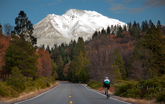
Prepare for visual treats today. Once you turn onto Callahan-Gazelle Road, you’ll ascend gradually enough that when you reach the rim of the canyon you didn’t know was there, it’ll take your breath away. View the thrilling descent from above, then dive in and enjoy it at your pace. Then, as you spin through another fertile valley, soak in majestic views of Mt. Shasta absolutely dominating the horizon on the way into Weed.

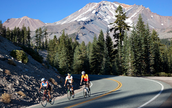
Day 6 – Friday, June 28: Weed Layover: Mt. Shasta Up-and-Back – 54 miles, 5,765 feet RWGPS route file
Site Location: Bel Air Park Map
Local lodging: Find local listings here.
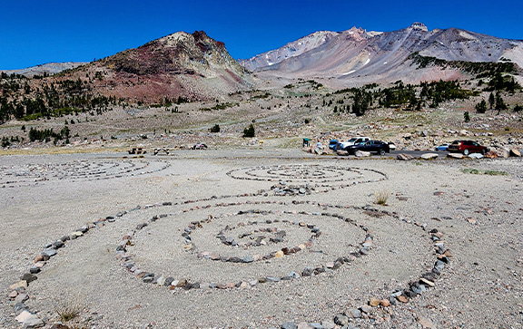
The native tribes of the region have an array of origin stories and spiritual connections to this mighty mountain, and you can tune into some of its singular energy on your ride today. Start with a rolling back-way route to the city named for the mountain, then begin your ascent. Don’t forget to take in the variety of vistas on the way up and down, and maybe take a few minutes to immerse yourself in a rock labyrinth at Panther Meadows, the end of the road.

Day 7 – Saturday, June 29: Weed to Yreka – 45 miles, 1,380 feet RWGPS route file
Site Location: Jackson Street Elementary School Map
Local Lodging (PDF)
You couldn’t ask for a better finishing day after a week of riding: short, mostly flat and tranquil. Not far to the north is Lava Beds National Monument, and the geography reflects it: grasslands and rocky terrain. More back roads will let you get into your flow and reflect on the highlights of your week of adventure, ending in Yreka. Another ride for the memory book.

CALIFORNIA 2024 RIDE LOGISTICS
Start Location
We’ll meet on Saturday, June 22, in Yreka; we’ll be staying at Jackson Street Elementary, where long-term parking will also be. The address is 405 Jackson Street, Yreka, CA 96097, for navigation devices.
Check-In
Check-in is on Saturday, June 22. We’ll be setting up camp in the morning, and our registration check-in station doesn’t open until 2 p.m. – we ask that you don’t try to come in and set up early; go check out the town! Dinner begins serving at 6 p.m., so it works best if you plan to arrive between 2 and 5. Check-in will stay open until 7; if you arrive later than that, we’ll check you in Sunday morning or after the Day 1 ride.
Driving to Jackson Street Elementary:
From Portland, allow 5-5.5 hours of driving time.
From Bend, allow 4 hours of driving time.
Parking
Long-term parking will be on the school grounds; signs and helpful crew members will direct you to the right spot.
Flying In
Rogue Valley International Medford Airport (MFR) is 54 miles away from Yreka and has flights on Alaska, American, Delta, United and Allegiant. There are two smaller airports near Yreka, Siskiyou County Airport and Montague-Yreka Airport.
Shuttle Service
We will have shuttle service available from the Medford airport to Yreka on Saturday, June 22, and back on Saturday, June 29. We’ll send details out to everyone registered, and we’ll post an update here.
Overnight Lodging
Yreka has multiple lodging options. (See attached lodging PDF)

Connect With Us
Contact
Newsletter
Sign up for our newsletter, to get all the BRNW news first.
Route History
Want to see everywhere we've been since 1987?
Click here for a PDF of all our routes since the humble beginning.
Imagery Credits
The following people have contributed photos and/or videos to the website:
- Burk Webb, Derailleur Films
- John Mejia
- Phil Bard, Bard Photography
- K’Lynn Lane, Memory Lane Photography
- Terry Poe, Poe Photography
- Mike Westby
- Jim Moore
- Alice Bonham
- Bill Buckley
- Miranda Morehouse
- Jack Newlevant